

A UAV autopilot needs a continuous, trustworthy navigation solution. When GNSS becomes unavailable or untrusted, the challenge is not simply to keep the aircraft in the air. The system must maintain the navigation performance required by the mission and identify when that performance can no longer be relied on.
A UAV can lose satellite visibility behind terrain or structures. Interference or deliberate jamming can prevent its receiver from tracking legitimate signals. Spoofing can be more difficult to recognize: a receiver may keep delivering coordinates, but those coordinates may be wrong.
The autopilot’s response is determined by the navigation architecture around it. That architecture must assess incoming measurements, maintain an estimate using trusted sources and communicate the quality of that estimate to the functions controlling the mission.
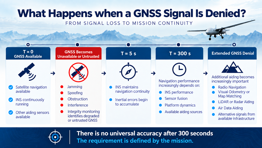
What happens after 300 seconds without reliable GNSS cannot be answered by the clock alone. It depends on the last trusted state, inertial performance, aircraft dynamics, integrity monitoring, sensor fusion, available aiding and operating environment. Above all, it depends on what accuracy the mission requires at that point.
What Does the Autopilot Know About GNSS?
An autopilot normally uses a navigation solution produced by a GNSS receiver, an INS or a combined navigation system. Depending on the integration, it may receive position, velocity, attitude, heading and time, together with status information or estimates of uncertainty.
Those details matter when GNSS is challenged. A position output that continues to update is not proof that it is trustworthy. Equally, loss of a GNSS fix does not mean that all navigation information disappears.
A resilient system needs a defined path from measurement to flight decision:
- Receiver and monitoring functions report signal quality, interference indications and measurement status.
- The navigation filter compares incoming measurements with its predicted state and other available sources. It accepts, reduces the weight of or rejects measurements according to its design.
- The autopilot and mission logic use the resulting estimate, its status and predefined operating limits to decide which task remains permissible.
Specific interfaces and behaviours vary between platforms. The engineering requirement must state what information the autopilot receives and how it should react when the navigation solution degrades.
Why Jamming and Spoofing Require Different Responses
When satellites are obstructed or a jammer prevents reception, the receiver may clearly report degraded tracking or loss of its position solution. The navigation system then has to continue without that external correction.
Spoofing challenges the integrity of a solution that may still appear available. False satellite-like signals can produce incorrect position, velocity or time information. If those measurements are accepted by the navigation filter, the estimated aircraft state can be displaced from its true state.
A useful integrity check therefore looks beyond whether a GNSS message has arrived. It can consider receiver diagnostics and whether the new measurements agree with inertial propagation and independent sensors. In a filter, the difference between a predicted measurement and an incoming one is often called an innovation or residual. An unexpected residual is evidence for investigation, although it does not identify every possible spoofing case by itself.
The navigation architecture should define what happens when a source is suspect: how it is excluded, which sources remain, what status is reported to the autopilot and what evidence is required before GNSS is trusted again.
T = 0: The Last Trusted State
The denied-navigation interval starts from the system’s last trusted estimate. At that moment, a GNSS-aided filter may have estimates of position, velocity, attitude, heading and inertial-sensor errors.
The quality of those estimates depends on what happened before the interruption. Alignment, calibration, temperature, antenna configuration, GNSS quality and the aircraft’s recent motion can all affect the starting uncertainty. A well-initialized system begins from a stronger state than one that was already poorly aligned or using degraded measurements.
Heading deserves particular attention. While GNSS is trustworthy, a dual-antenna GNSS/INS configuration can provide a precise heading reference. Once GNSS measurements are rejected, that satellite-derived heading update is no longer available. The system must maintain its heading estimate using inertial measurements and any other suitable references.
This means a GNSS-denied test should document its starting conditions. A result obtained after careful alignment cannot automatically be applied to an aircraft that enters the outage with a different state.
GNSS Is Lost or Rejected: What Continues?
An INS continues to measure angular motion and specific force with its gyroscopes and accelerometers. Its processor propagates attitude, velocity and position from the last estimated state. The navigation solution can therefore remain continuous even after trusted GNSS corrections stop.
The filter should no longer allow measurements it has rejected to pull that solution toward an untrusted position. It should also represent the increasing uncertainty of states that no longer receive an adequate external correction.
This is where continuity and integrity meet. Continuing to output coordinates is useful only if the aircraft knows what confidence to place in them. An autopilot might still have sufficient attitude information for controlled flight while absolute position has become unsuitable for a more demanding route or approach.
Protected GNSS can reduce the likelihood of reaching this state under some interference conditions. General Guidance offers Inertial Labs TwoSents for detection and mitigation of jamming and spoofing and the JAVAD TR-2S AJ GNSS receiver with in-band interference rejection and related detection functions. These technologies strengthen the GNSS layer. The aircraft still needs an INS and mission response for conditions in which a trustworthy GNSS solution cannot be maintained.
T = 5 s: Continuity Is Visible; Error Growth Has Begun
In the first moments without trusted GNSS, the INS continues supplying a high-rate motion estimate. The autopilot need not lose all position, velocity and attitude information when the GNSS receiver loses its fix.
But inertial errors begin accumulating as soon as external corrections are unavailable. The significance of those errors depends on the task. The aircraft may have adequate information to maintain controlled flight, yet a precise geographic task can have a stricter position requirement.
The T = 5 s point in the newsletter graphic illustrates this transition to inertial continuity. It is not a universal specification for the accuracy of every INS at five seconds.
T = 300 s: Can the Aircraft Still Meet Its Mission Requirement?
At T = 300 s, the INS may still be producing a smooth, continuous navigation solution. Smoothness does not establish that its position is sufficiently accurate. The engineering assessment has to compare the aircraft’s actual and estimated navigation performance against a defined requirement.
Suppose a mission sets a maximum allowable horizontal position error for a particular flight phase. The team must then test the complete aircraft through a representative GNSS-denied interval and evaluate its position error at 300 seconds. It should also examine heading, velocity, attitude and any other state required for that task.
The statistical meaning of each figure must be explicit. An RMS value, a CEP50 value and a maximum permitted error are different metrics. A GNSS-aided centimetre-level position specification must not be treated as the position accuracy the aircraft retains after five minutes without GNSS.
The filter’s reported uncertainty is also important. It should be checked for consistency with measured errors in representative tests. A system that is wrong but reports high confidence is a different problem from one that accurately reports that its position is becoming uncertain.
There is therefore no universal accuracy after 300 seconds. The result belongs to a specified sensor configuration, aircraft, flight profile, aiding set and environment.
What Controls the Result at 300 Seconds?
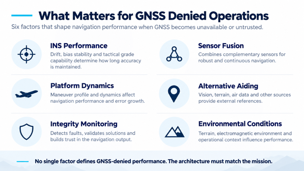
The newsletter identifies six interacting factors. Each should be considered when interpreting a GNSS-denied test or choosing hardware.
1. INS Performance
Gyroscope and accelerometer errors accumulate through integration. Bias stability, calibration and temperature behaviour affect the growth of attitude, velocity and position error. A compact MEMS INS and a higher-performance tactical or FOG-based configuration serve different error budgets.
An accelerometer bias can contribute to growing velocity and position error. Gyroscope error can alter the attitude estimate and cause gravity to be projected incorrectly into horizontal motion. Calibration and estimation reduce these effects but cannot make an unaided INS an unlimited absolute reference.
2. Platform Dynamics
A steady fixed-wing flight, a highly manoeuvring multirotor and a vibrating aircraft place different demands on the inertial sensors and filter. Angular rates, acceleration, vibration and mounting quality all affect performance.
An outage result measured on one motion profile should not be presented as the expected result for another. Tests must include the flight phases for which the requirement applies.
3. Integrity Monitoring
Availability answers whether a measurement or solution exists. Integrity addresses whether it should be trusted for the intended use.
Receiver diagnostics, filter residuals and comparison with independent sources can help identify faults. The system must also state what status reaches the autopilot when a source is rejected and when the remaining estimate no longer meets the mission limit.
4. Sensor Fusion
A filter can combine GNSS, inertial data and other measurements according to their estimated quality. Its performance depends on correct calibration, time synchronization, sensor mounting, uncertainty models and fault handling.
More sensors are not automatically better. A delayed, misaligned or faulty aiding source can make the estimate worse if its measurements are accepted without suitable checks.
5. Alternative Aiding
Vision, air data, radar, LiDAR, terrain information and alternative radio signals can supply measurements independent of conventional GNSS. They observe different things. Airspeed can help constrain motion but does not report geographic position. Visual odometry estimates relative movement; absolute visual positioning needs a suitable external reference.
Aiding should be selected according to the navigation state the mission needs to constrain.
6. Environmental Conditions
Lighting, terrain texture, weather, magnetic disturbance and the RF environment influence which aiding sources work. Vision may have limited features in a uniform scene. A magnetic heading measurement may be disturbed. An alternative signal can have its own availability and interference limits.
The required performance must be demonstrated under the conditions in which the UAV is expected to operate.
GNSS-Denied Navigation Is an Architecture
No single component addresses all six factors. A protected receiver can improve GNSS availability and help detect interference, but it does not replace inertial continuity. An INS provides continuity, but it drifts. A camera or air-data sensor contributes useful information only under the right conditions and through suitable integration. Integrity monitoring connects measurement quality to the aircraft’s decisions.
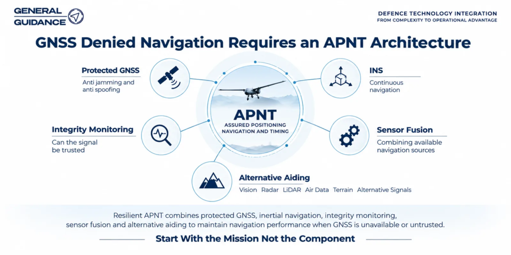
The APNT architecture in the newsletter brings those functions together:
- Protected GNSS: Retain valid external measurements where possible and report interference-related conditions.
- INS: Propagate motion and navigation states when GNSS cannot be used.
- Integrity monitoring: Identify suspect inputs and assess whether the output is fit for the task.
- Sensor fusion: Combine valid measurements with suitable timing and uncertainty models.
- Alternative aiding: Constrain drift or provide another external reference.
The output of that architecture must reach the autopilot in a form it can use. Position and velocity alone may be insufficient if the mission must respond to declining confidence. Navigation mode, source status and uncertainty or other appropriate quality indicators need to be considered in the integration.
Where the General Guidance Products Fit
Products should be considered by function, then checked against the specific aircraft and mission.
For GNSS protection, TwoSents and JAVAD TR-2S AJ address interference awareness and mitigation. The JAVAD TR-2S AJ INS combines a protected GNSS receiver with calibrated, temperature-compensated inertial sensors and full attitude determination in a compact OEM format. These options do not imply identical interfaces or denied-navigation performance; the selected configuration must be checked.
For inertial continuity, the Inertial Labs INS range includes compact OEM systems, single- and dual-antenna configurations, rugged INS-DM systems and FOG-based options. Their sensor characteristics, heading sources, size and integration features differ. A dual-antenna GNSS heading advantage applies while the satellite measurements are trusted; the denied interval must be evaluated using the remaining sources.
For airborne aiding, INS-U and INS-U-OEM integrate INS, AHRS and Air Data Computer functions. A standalone Inertial Labs ADC is another integration option. Pressure and airspeed-related data can assist estimation for suitable aircraft, but do not themselves provide an absolute geographic fix.
For visual aiding, VINS combines inertial and machine-vision capabilities. Its VIO and VPS functions have different meanings: relative motion estimation should not be described as absolute positioning without an appropriate reference. Performance depends on the visual operating conditions.
For a different external reference, IRINS and IRINS-DM introduce LEO-based Iridium STL aiding. IRINS-DM is a particular integrated GNSS/LEO/INS configuration; its onboard transcoder is optional. The selected version and its service requirements must be checked for the platform.
This is a set of architectural options, not a product ranking or a promise that combining them will produce a particular position error at T = 300 s.
What Happens Beyond 300 Seconds?
If the mission continues through a longer GNSS-denied interval, the aircraft needs to keep assessing whether its estimate remains fit for its task. Inertial-only uncertainty may continue to grow. Independent aiding becomes more valuable when it supplies valid information that constrains the states relevant to the mission.
A visual system may help in a scene with suitable features but contribute less under different lighting or terrain. Air data can remain useful for flight-state estimation without restoring absolute position. A LEO-derived reference may provide another external measurement when available. The filter must account for each source’s limits and for the loss of a source during flight.
The autopilot’s permitted response should be defined in advance. It may continue a task while required limits are met, change the route, seek a recovery area or use another approved procedure when they are not. The particular response is a platform and mission design decision, not an inherent feature of every INS.
When GNSS becomes available again, the system should verify its consistency before allowing it to correct the navigation estimate. Reacquisition should not automatically turn an untrusted measurement into a trusted one.
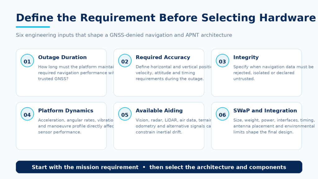
Define the Requirement Before Choosing Hardware
The newsletter ends with the right starting point:
How long does the platform need to continue operating without reliable GNSS, and what navigation accuracy must remain during that period?
For the scenario shown here, 300 seconds is an evaluation point. The requirement must also define what is acceptable at that point:
- Horizontal and vertical position performance.
- Velocity, heading and attitude performance needed by the task.
- Any separate requirement for reliable timing.
- The statistical measure used for each accuracy figure.
- The GNSS failure or threat being tested.
- The aircraft’s motion, environment and pre-outage alignment.
- The aiding sources expected to remain available.
- The navigation status or limit that triggers a change of mission mode.
“Operates without GPS for 300 seconds” is not sufficient as an acceptance criterion. It says nothing about the accuracy, integrity or task that must remain possible. A testable requirement connects the denied interval to measurable navigation limits and an explicit aircraft response.
Test the Whole Navigation Chain
A datasheet is necessary for selecting candidates, but the complete UAV determines mission performance. A representative test should include the antenna and receiver, interference indicators, INS, aiding sensors, filter, autopilot interface and flight logic.
Record the last trusted state before denial. Introduce the defined GNSS loss or threat. Measure actual position, velocity, attitude and heading errors during the interval and at T = 300 s. Compare them with the stated metrics and limits. Check whether the filter’s uncertainty and integrity status reflect the observed result.
The test should also show what the autopilot does when the navigation limit is reached and how the system validates GNSS when it returns. Vibration, manoeuvres, installation and environment should represent the intended aircraft operation.
A flight result on one platform is evidence for that configuration and test profile. It is not a universal five-minute performance specification for every UAV carrying the same component.
Start With the Mission, Not the Component
When a UAV experiences jamming, spoofing or GNSS denial, its navigation system should determine whether GNSS remains trustworthy, propagate the aircraft state with an INS when it does not, use valid independent aiding and communicate the quality of the resulting estimate.
At 300 seconds, the decisive question is not whether the autopilot is still receiving coordinates. It is whether the aircraft still meets the navigation accuracy and integrity required by its mission.
General Guidance supports the selection and integration of protected GNSS, inertial navigation, air-data, vision and alternative aiding technologies for UAS and other mission-critical platforms. The right starting point is the expected denial scenario, required performance at 300 seconds and the aircraft’s available sensors.