

Global Navigation Satellite System, or GNSS, is the general term for satellite-based systems that provide positioning, navigation and timing information to users around the world. GNSS enables devices, vehicles, aircraft, ships, unmanned platforms and critical infrastructure systems to determine where they are, where they are going and what precise time reference they should use.
While GPS is the best-known satellite navigation system, it is only one part of the broader GNSS ecosystem. Other major systems include Galileo, GLONASS and BeiDou, together with regional augmentation systems that improve accuracy, availability and reliability.
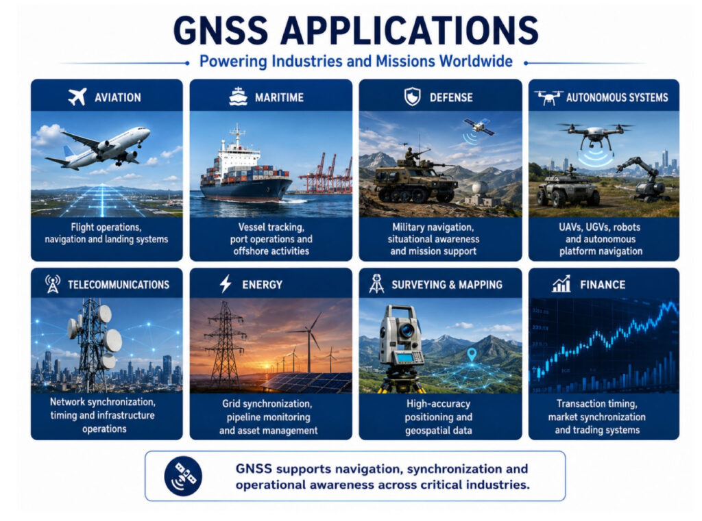
Today, GNSS is deeply integrated into modern operations. It supports civilian navigation, aviation, maritime operations, autonomous systems, surveying, telecommunications, energy networks, financial transactions and defense applications. In many sectors, GNSS is not only a convenience; it is a core enabler of operational capability.
GNSS vs GPS: What Is the Difference?
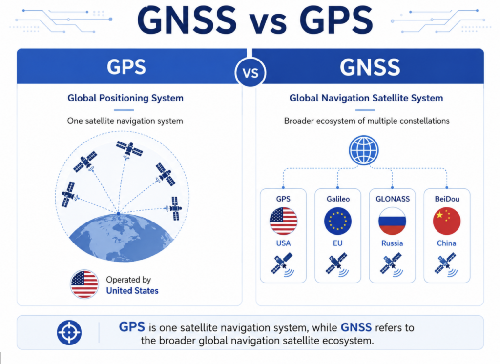
GPS, or the Global Positioning System, is the satellite navigation system operated by the United States. GNSS is the broader category that includes GPS and other global or regional satellite navigation systems. In practical terms, a GNSS receiver may use signals from multiple constellations, such as GPS, Galileo, GLONASS and BeiDou. This multi-constellation capability can improve satellite availability, positioning performance and resilience, especially in challenging environments where part of the sky may be blocked or signal conditions are degraded.
How GNSS Works
GNSS satellites orbit the Earth and continuously transmit radio signals containing timing and orbital information. A GNSS receiver uses these signals to calculate its distance from several satellites. By comparing the signal travel time from multiple satellites, the receiver can estimate its position.
A typical GNSS solution requires signals from at least four satellites to calculate latitude, longitude, altitude and time. The accuracy of the result depends on several factors, including satellite geometry, signal quality, atmospheric effects, receiver performance and the surrounding environment.
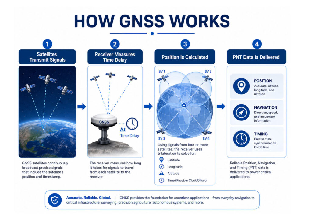
GNSS provides three essential functions:
Positioning – determining the user’s location on or near the Earth.
Navigation – supporting movement from one location to another.
Timing – providing precise time synchronization for systems that must operate together.
This combination is often referred to as PNT: Positioning, Navigation and Timing.
Why GNSS Is Important
GNSS is one of the most important technologies behind modern mobility and digital infrastructure. It supports everyday navigation, but its role extends far beyond maps and route guidance.
In aviation, GNSS contributes to en-route navigation, approach procedures and air traffic management. In maritime operations, it supports vessel tracking, port operations and offshore activities. In land systems, it enables fleet management, logistics, precision agriculture and autonomous vehicle navigation.
GNSS timing is equally important. Telecommunications networks, power grids, financial systems and distributed digital infrastructure often depend on precise timing references to maintain synchronization. Even when location is not the main requirement, GNSS timing can be mission-critical.
GNSS in Defense and Mission-Critical Operations
For defense, aerospace and unmanned systems, GNSS provides essential navigation and synchronization data. Military vehicles, drones, vessels, sensors, communication systems and command platforms often rely on accurate PNT information to operate effectively.
However, defense environments are rarely ideal. Operations may take place in areas affected by electronic warfare, signal obstruction, terrain masking, urban canyons or intentional interference. In these scenarios, GNSS alone may not be sufficient.
This is why modern mission-critical platforms increasingly require resilient navigation architectures that combine GNSS with inertial navigation systems, IMUs, anti-jamming technology, anti-spoofing methods, sensor fusion and alternative PNT sources.
Key GNSS Limitations
GNSS signals are transmitted from satellites thousands of kilometers above Earth. By the time they reach the receiver, they are extremely weak. This makes them vulnerable to environmental conditions and intentional interference.
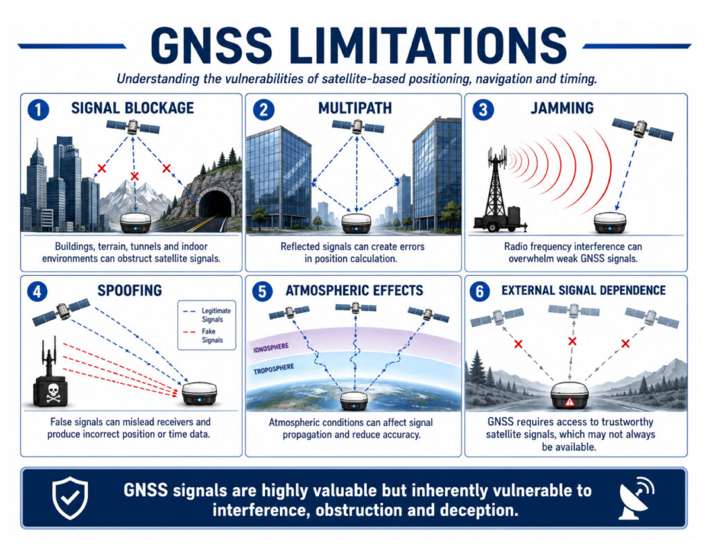
Common GNSS limitations include:
Signal blockage – buildings, terrain, tunnels, dense forests or indoor environments can block satellite signals.
Multipath – signals can reflect from buildings, metal structures or water surfaces, causing positioning errors.
Jamming – radio frequency interference can overpower GNSS signals and prevent the receiver from calculating a position.
Spoofing – false GNSS-like signals can mislead a receiver into calculating an incorrect position or time.
Atmospheric effects – ionospheric and tropospheric conditions can affect signal propagation and accuracy.
Dependence on external signals – GNSS requires access to satellite signals, which may not always be available or trustworthy.
These limitations do not reduce the importance of GNSS. Instead, they highlight the need to understand where GNSS performs well and where additional technologies are required.
GNSS-Denied and GNSS-Challenged Environments
A GNSS-denied environment is an operational area where satellite navigation signals are unavailable, blocked, jammed or unreliable. A GNSS-challenged environment is one where signals may still be present, but their quality or trustworthiness is reduced.
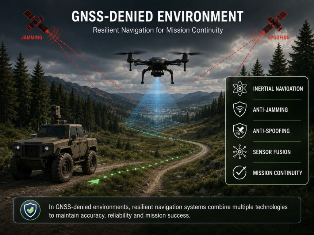
Examples include:
Urban areas with high-rise buildings
Mountainous or forested terrain
Indoor facilities, tunnels and underground structures
Military conflict zones
Areas affected by jamming or spoofing
Maritime environments with electronic interference
Drone operations near critical infrastructure or contested areas
In these environments, relying only on GNSS can create operational risk. Platforms may lose position accuracy, navigation continuity or timing integrity. For autonomous and defense systems, this can directly affect mission success and platform safety.
From GNSS to Resilient PNT
Modern navigation is moving from single-source GNSS dependency toward resilient PNT architectures. The goal is not to replace GNSS, but to strengthen it with complementary technologies.
A resilient PNT system may include:
Multi-constellation and multi-frequency GNSS
Inertial Navigation Systems
IMUs and motion sensors
Anti-jamming antennas
Anti-spoofing detection
Sensor fusion algorithms
Vision, LiDAR or radar-based navigation
Alternative timing sources
LEO-based signal support
Mission-specific navigation software
By combining these technologies, systems can continue operating when GNSS is degraded, disrupted or unavailable.
GNSS and Inertial Navigation
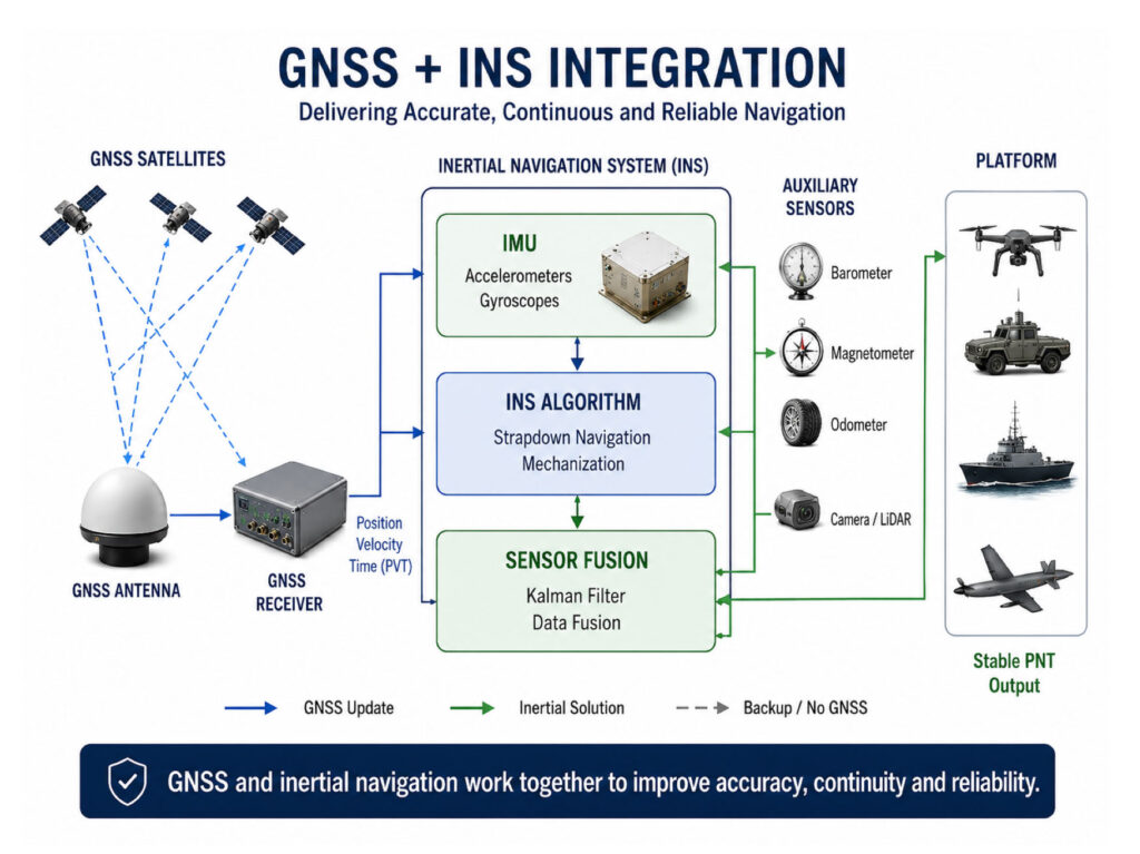
Inertial navigation is one of the most important complements to GNSS. Unlike GNSS, inertial systems do not depend on external satellite signals. Instead, they use accelerometers and gyroscopes to measure motion and estimate position, velocity and orientation.
When GNSS is available, it can help correct inertial drift. When GNSS is lost, the inertial system can continue providing navigation data for a period of time. This combination is widely used in unmanned systems, defense platforms, aerospace systems, maritime navigation and land vehicles.
The integration of GNSS and INS provides better continuity, stability and resilience than GNSS alone.
The Future of GNSS
GNSS will remain a foundation of global navigation, but future systems will increasingly be designed around resilience. More platforms will use multi-layered navigation architectures that can operate across open-sky, degraded, contested and denied environments.
The future of GNSS is not only about higher accuracy. It is about trust, continuity and assured performance.
For defense, autonomous systems and critical infrastructure, the key question is no longer simply “Can the system receive GNSS?” The more important question is: “Can the system continue to navigate when GNSS cannot be trusted?”
Conclusion
GNSS is one of the core technologies enabling modern positioning, navigation and timing. It supports global mobility, infrastructure synchronization, autonomous operations and mission-critical systems across land, sea, air and space.
However, GNSS is not immune to disruption. Signal blockage, interference, jamming and spoofing can reduce reliability, especially in complex or contested environments.
For modern defense and aerospace applications, GNSS should be viewed as an essential component within a broader resilient navigation architecture. By combining GNSS with inertial navigation, anti-jamming, anti-spoofing and sensor fusion technologies, organizations can maintain reliable PNT performance even when satellite signals are degraded or denied.
General Guidance supports advanced navigation and resilient PNT solutions for platforms operating in demanding environments, helping customers strengthen navigation performance where accuracy, continuity and reliability are mission-critical.