
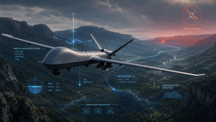
Modern platforms depend on accurate and continuous navigation data. Aircraft, unmanned systems, ground vehicles, maritime platforms and defense applications all require reliable information about position, velocity, orientation and time.
For decades, Global Navigation Satellite Systems (GNSS), including GPS, have provided highly accurate positioning. However, GNSS signals are external, weak and vulnerable to interference, obstruction, jamming and spoofing. In contested or complex environments, satellite-based navigation alone may not be sufficient.
This is where inertial navigation becomes critical.
Inertial navigation is a self-contained navigation method that uses motion sensors to calculate a platform’s position, velocity and attitude without relying on external signals. Unlike GNSS, inertial systems do not require satellites, radio signals or external infrastructure to continue operating.
What Is Inertial Navigation?
Inertial navigation is based on measuring movement from within the platform itself. An inertial navigation system uses sensors to detect acceleration and rotation, then calculates how the platform is moving over time.
A typical inertial navigation system can provide:
- Position
- Velocity
- Roll, pitch and yaw
- Heading
- Acceleration
- Angular rate
- Attitude and orientation data
Because it operates independently, inertial navigation is especially important in environments where GNSS is degraded, denied or intentionally disrupted.
Key Components of an Inertial Navigation System
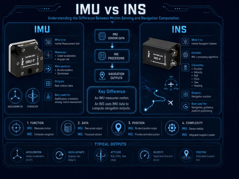
IMU – Inertial Measurement Unit
The IMU is the core sensing element of an inertial navigation system. It typically includes accelerometers and gyroscopes.
Accelerometers measure linear acceleration along different axes.
Gyroscopes measure angular rotation and changes in orientation.
Together, these sensors provide the raw motion data required for inertial navigation.
INS – Inertial Navigation System
An INS uses IMU measurements together with advanced algorithms to calculate navigation outputs such as position, velocity and attitude. While an IMU measures motion, an INS processes that motion into usable navigation data.
Sensor Fusion
In many modern systems, inertial navigation is combined with GNSS, magnetometers, barometers, odometers, LiDAR, cameras or other sensors. This process is known as sensor fusion.
Sensor fusion improves accuracy, stability and reliability, especially during GNSS outages or in challenging operational environments.
How Inertial Navigation Works
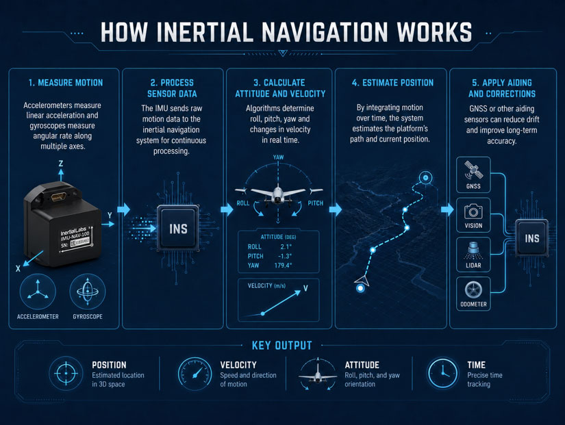
Inertial navigation begins with a known starting point. From that point, the system continuously measures acceleration and rotation. By integrating this data over time, the system estimates how the platform has moved.
The basic process includes:
- Measuring acceleration and angular rate
- Calculating changes in velocity and attitude
- Estimating position based on movement over time
- Correcting accumulated errors when external reference data is available
- Providing continuous navigation output to the platform or mission system
This allows the platform to maintain navigation even when external signals are unavailable.
Why Inertial Navigation Is Important
GNSS provides excellent accuracy when available, but it is not always reliable in real-world operations. Satellite signals may be blocked by terrain, buildings, tunnels, dense vegetation or indoor environments. In military and defense scenarios, GNSS can also be intentionally jammed or spoofed.
Inertial navigation provides a resilient alternative because it does not depend on external signals.
This makes INS technology essential for:
- GNSS-denied operations
- Anti-jamming and anti-spoofing navigation
- Defense and aerospace platforms
- Autonomous systems
- UAV, UGV and USV navigation
- Maritime and land navigation
- Precision targeting and stabilization
- Mission-critical positioning and orientation
INS and GNSS: Complementary Technologies
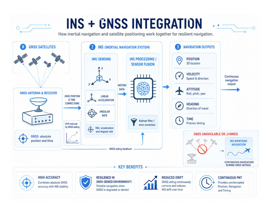
Inertial navigation and GNSS are not competing technologies. In many applications, they work together.
GNSS provides accurate absolute positioning when signals are available. INS provides continuous navigation during signal loss, interference or temporary outages. When integrated properly, the two technologies create a stronger and more reliable navigation solution.
A GNSS-aided INS can use satellite positioning to correct inertial drift. When GNSS becomes unavailable, the INS continues providing navigation data until the signal returns or another aiding source is used.
This combination is especially valuable for platforms operating in complex or contested environments.
Inertial Drift and Accuracy
One of the key technical challenges of inertial navigation is drift.
Because an INS calculates position by continuously integrating sensor measurements, small sensor errors can accumulate over time. This means that inertial navigation accuracy depends heavily on sensor quality, calibration, environmental stability and the use of correction methods.
Higher-grade inertial systems provide better long-term accuracy and lower drift. In demanding applications, INS performance may be improved through GNSS aiding, odometer input, visual navigation, LiDAR, barometric data or advanced sensor fusion algorithms.
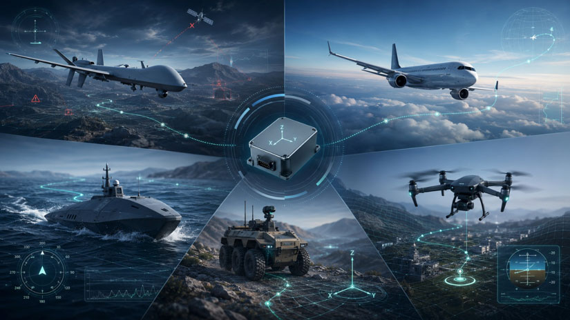
Types of Inertial Navigation Applications
Defense Platforms
In defense applications, inertial navigation supports reliable operation in electronic warfare and GNSS-contested environments. It enables navigation, stabilization, targeting and mission continuity when satellite signals are compromised.
Unmanned Systems
UAVs, UGVs and USVs require continuous navigation data to operate safely and accurately. INS technology enables unmanned platforms to maintain orientation, follow routes and continue missions in areas where GNSS may be weak, blocked or disrupted.
Aerospace
Aircraft and advanced airborne systems use inertial navigation for attitude, heading, position and velocity data. INS technology is critical for flight control, navigation backup and mission systems.
Maritime Navigation
Maritime platforms use inertial navigation for heading, stabilization, positioning and operations where GNSS may be unreliable or unavailable.
Land Vehicles
Ground vehicles can use inertial navigation together with odometers, GNSS or other sensors to maintain positioning in urban canyons, tunnels, forests or contested environments.
Inertial Navigation in GNSS-Denied Environments
GNSS-denied environments are becoming increasingly relevant for defense, security and autonomous operations. In these scenarios, navigation systems must continue operating even when satellite signals are unavailable or intentionally disrupted.
Inertial navigation provides the foundation for resilient navigation in these conditions. When combined with other aiding technologies, INS can help maintain accurate positioning and orientation during GNSS outages.
For modern platforms, inertial navigation is not only a backup system. It is a core technology for assured positioning, navigation and timing.
The Role of Inertial Navigation in APNT
Assured Positioning, Navigation and Timing, or APNT, requires reliable navigation data under all operational conditions. Inertial navigation is one of the key technologies within APNT architecture.
By providing independent and continuous motion-based navigation, INS technology strengthens platform resilience and reduces dependence on GNSS. In combination with anti-jamming, anti-spoofing, alternative signals and sensor fusion, inertial navigation supports mission continuity in challenging environments.