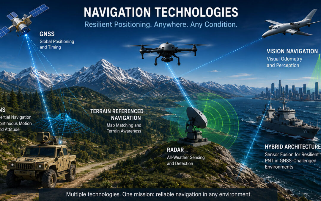
Modern platforms depend on accurate, continuous and trustworthy navigation. Aircraft, unmanned aerial vehicles, ground vehicles, maritime platforms, autonomous systems and defense applications all require reliable information about position, velocity, orientation and time.
For many years, Global Navigation Satellite Systems, including GPS, Galileo, GLONASS and BeiDou, have provided the foundation for global positioning, navigation and timing. GNSS remains one of the most important navigation technologies in the world. It is accurate, globally available and deeply integrated into civil, commercial and defense systems.
However, GNSS is not always available or reliable. Satellite signals can be blocked by buildings, terrain, forests, tunnels or indoor environments. They can also be degraded by interference, jamming, spoofing or other electromagnetic effects. In mission-critical operations, relying on a single source of navigation data can create operational risk.
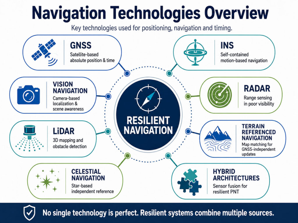
This is why modern navigation is moving toward multi-sensor and hybrid architectures. Instead of depending only on GNSS, resilient systems combine several technologies, such as inertial navigation, vision-based navigation, radar, LiDAR, terrain referenced navigation, celestial navigation and advanced sensor fusion.
The goal is not to replace GNSS. The goal is to create navigation systems that can continue operating when GNSS is degraded, denied or no longer trustworthy.
What Navigation Systems Need to Deliver
A navigation system must answer several essential questions:
Where is the platform?
How fast is it moving?
What direction is it facing?
What is its attitude, including roll, pitch and yaw?
Can the data be trusted?
Can navigation continue if one sensor fails or becomes unavailable?
Different technologies answer these questions in different ways. Some provide absolute position. Others provide relative motion, terrain awareness, environmental perception or backup reference data. The most effective solutions usually combine several sources into one reliable navigation output.
This is especially important for defense, aerospace, unmanned and autonomous systems, where navigation performance can directly affect safety, mission success and operational continuity.
GNSS: Global Satellite-Based Positioning
GNSS provides positioning, navigation and timing by using signals transmitted from satellites. A GNSS receiver calculates its position by measuring the signal travel time from multiple satellites and using that data to estimate location and time.
GNSS is highly valuable because it provides global coverage, absolute position and precise timing. It is widely used in aviation, maritime operations, surveying, autonomous platforms, telecommunications, logistics, agriculture and defense systems.
The main strengths of GNSS include:
Global availability
Accurate absolute positioning
Precise timing
Mature receiver technology
Multi-constellation and multi-frequency capability
Integration with augmentation systems and correction services
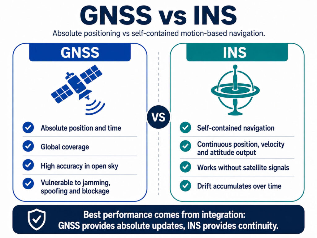
However, GNSS has important limitations. The signals are weak by the time they reach the receiver. They can be obstructed, reflected, jammed or spoofed. GNSS also depends on external satellite signals, meaning that navigation performance may degrade in urban canyons, tunnels, dense vegetation, mountainous terrain, indoor environments or contested electromagnetic environments.
GNSS is therefore an excellent navigation source when signals are available and trustworthy. It is not sufficient as the only source for platforms that must operate through interference, obstruction or deliberate attack.
INS: Inertial Navigation Systems
An Inertial Navigation System, or INS, calculates position, velocity and attitude by measuring motion. It uses accelerometers to measure linear acceleration and gyroscopes to measure angular rate. Based on this motion data, the system estimates how the platform moves from a known starting point.
Unlike GNSS, INS does not require satellite signals, radio infrastructure or external references to continue operating. This makes inertial navigation extremely important in GNSS-denied and GNSS-degraded environments.
The main strengths of INS include:
Self-contained operation
Continuous navigation output
High update rate
Attitude, heading and motion data
Strong performance during short GNSS outages
Resistance to jamming and signal blockage
The main limitation of INS is drift. Small measurement errors accumulate over time. Without correction from GNSS or another aiding source, position accuracy gradually degrades. Higher-grade IMUs and gyroscopes reduce this drift, but they do not remove it completely.
For this reason, INS is often integrated with GNSS, odometers, barometers, magnetometers, vision systems, LiDAR, radar, Doppler sensors or other aiding sources. In hybrid systems, INS provides continuity while external sensors provide corrections.
Vision-Based Navigation
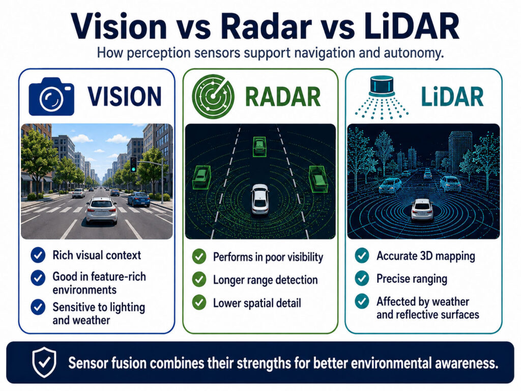
Vision-based navigation uses cameras and image-processing algorithms to estimate motion, position or orientation. It may rely on visual odometry, simultaneous localization and mapping, feature tracking, object recognition or comparison with known visual references.
Vision navigation is especially useful for drones, autonomous vehicles, robotics and platforms operating in areas where GNSS is unreliable. Cameras can provide rich environmental information and help the system understand movement relative to visible features.
The main strengths of vision-based navigation include:
Passive sensing
Useful for autonomy and obstacle awareness
Strong performance in feature-rich environments
Support for indoor and urban navigation
Compatibility with AI-based perception systems
However, vision navigation is highly dependent on environmental conditions. Performance can degrade in darkness, fog, smoke, dust, heavy rain, snow, glare or featureless terrain such as water, sand or uniform surfaces. It also requires processing power and careful calibration.
Vision-based navigation is therefore powerful, but it is rarely ideal as a standalone navigation source for all conditions. It is most effective when combined with INS, GNSS, LiDAR, radar or terrain reference data.
These sensors provide the motion data required for accurate inertial navigation.
By comparing multiple data sources, navigation systems improve accuracy and reliability.
Radar Navigation
Radar uses radio waves to detect objects, measure range and support environmental awareness. In navigation, radar can assist with obstacle detection, terrain mapping, relative positioning, landing support, maritime navigation and operation in low-visibility environments.
Radar is valuable because it can operate in conditions where optical sensors may struggle. It can work through darkness, smoke, dust, fog or poor weather depending on the radar type, frequency and system design. This makes it highly relevant for aviation, maritime, autonomous ground vehicles and defense applications.
The main strengths of radar navigation include:
Operation in low visibility
Longer-range detection
Relative positioning and obstacle awareness
Useful performance in adverse weather
Strong relevance for maritime, airborne and defense systems
The limitations include lower resolution than camera or LiDAR systems in many applications, system complexity, integration cost and potential interference. Radar also requires careful signal processing and interpretation.
Radar is often used as an aiding and perception sensor rather than a complete navigation solution. When fused with INS, GNSS, vision or LiDAR, it can significantly improve situational awareness and navigation robustness.
LiDAR Navigation
LiDAR, or Light Detection and Ranging, uses laser pulses to measure distance and create high-resolution 3D information about the surrounding environment. It is widely used in mapping, surveying, robotics, autonomous vehicles and remote sensing.
For navigation, LiDAR can support localization, obstacle detection, mapping, terrain awareness and simultaneous localization and mapping. It is particularly useful when the system needs detailed geometric information about the environment.
The main strengths of LiDAR include:
High-resolution 3D perception
Accurate range measurement
Strong mapping capability
Useful for obstacle avoidance and autonomy
Support for SLAM and terrain modeling
The limitations include sensitivity to certain weather conditions, airborne particles, reflective surfaces and cost depending on the performance level required. LiDAR may also require significant processing power, especially for real-time navigation and mapping.
LiDAR is highly effective for autonomy and precision mapping, but it is usually stronger as part of a sensor fusion architecture than as a standalone navigation source.
Terrain Referenced Navigation
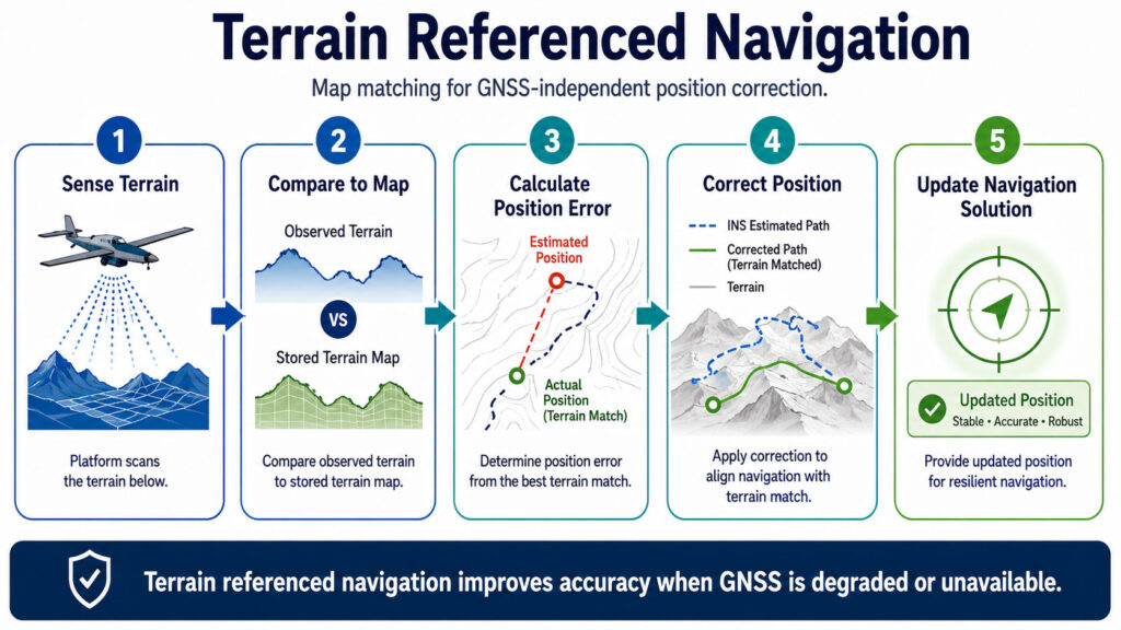
Terrain Referenced Navigation, also known as terrain relative navigation or terrain matching, estimates position by comparing sensor data with stored maps or terrain models. The platform uses radar, LiDAR, camera imagery or other sensors to observe the environment and match what it sees to a reference map.
This approach is especially relevant where GNSS is unavailable or unreliable. It can support aircraft, missiles, UAVs, ground vehicles, spacecraft landing systems and autonomous platforms operating over mapped terrain.
The main strengths of terrain referenced navigation include:
GNSS-independent localization
Use of existing terrain or map data
Strong value for low-altitude and terrain-following operations
Support for autonomous landing and route correction
Compatibility with radar, LiDAR and vision sensors
The limitations include dependence on accurate reference maps, recognizable terrain features and suitable sensor data. Performance may degrade over flat, repetitive, featureless or changing terrain. Snow, vegetation growth, construction, flooding or seasonal changes can also affect map matching.
Terrain referenced navigation is most effective when integrated with INS. The INS provides continuous motion estimation, while terrain matching periodically corrects position drift.
Celestial Navigation
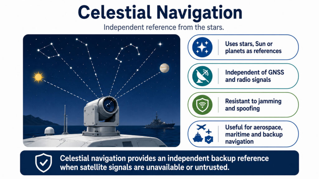
Celestial navigation uses stars, the Sun, planets or other celestial bodies as reference points. Historically, it was used by sailors and aviators. Today, modern celestial navigation can use star trackers, optical sensors and automated algorithms.
Celestial navigation is attractive because it does not depend on GNSS signals or terrestrial radio infrastructure. It can provide an independent reference, especially for aircraft, ships, spacecraft and long-endurance platforms.
The main strengths of celestial navigation include:
Independence from GNSS
Resistance to radio-frequency jamming
Usefulness for long-range and strategic platforms
Relevance for space, maritime and high-altitude applications
Strong value as a backup or aiding source
The limitations are practical. Celestial navigation requires visibility of celestial references. Clouds, daylight conditions, atmospheric effects, obscuration and platform motion can affect performance. It may also provide lower update rates than inertial or GNSS systems.
Modern celestial navigation is not usually a primary navigation system for most tactical platforms. However, it can be an important backup or aiding source in resilient navigation architectures.
Hybrid Navigation Architectures
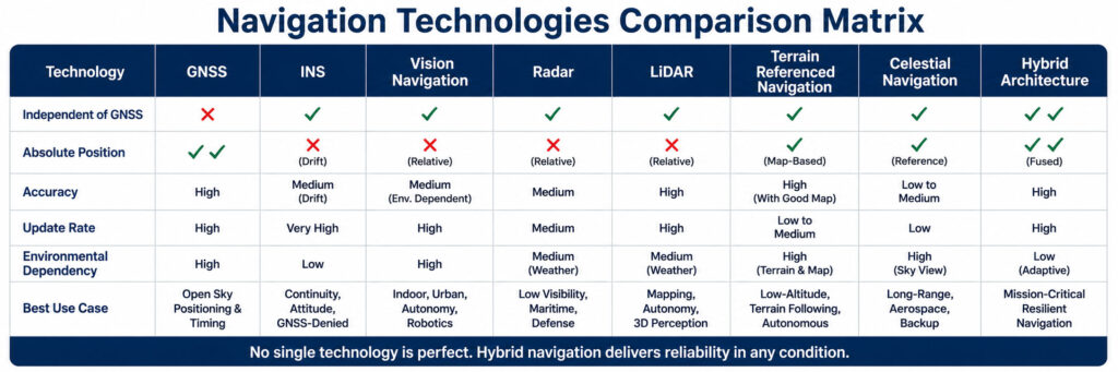
No single navigation technology is perfect. GNSS provides absolute position and timing, but it is vulnerable to disruption. INS provides continuous self-contained navigation, but it drifts over time. Vision and LiDAR provide environmental perception, but they depend on visibility and scene conditions. Radar can perform in poor visibility, but requires complex processing. Terrain referenced navigation can correct drift, but depends on maps and recognizable terrain. Celestial navigation is independent, but not always available.
Hybrid navigation architectures combine these technologies to reduce the weakness of each individual source.
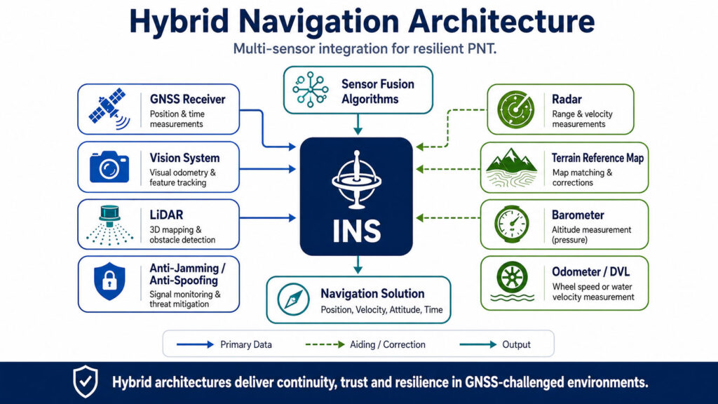
A typical resilient navigation architecture may include:
GNSS for absolute position and time
INS for continuous motion-based navigation
Vision for visual odometry and scene understanding
LiDAR for 3D mapping and obstacle detection
Radar for range, terrain and low-visibility sensing
Terrain referenced navigation for map-based correction
Celestial navigation for independent long-range reference
Sensor fusion algorithms to combine all available data
The core of many hybrid systems is sensor fusion. Algorithms such as Kalman filters, extended Kalman filters and advanced AI-assisted methods evaluate different sensor inputs, estimate uncertainty and produce a stable navigation output.
The system must also assess trust. If GNSS data appears inconsistent with inertial or terrain data, it may be rejected or downgraded. If vision is degraded by fog or darkness, radar or INS may become more important. If terrain matching is unavailable, GNSS or celestial updates may provide correction.
The best navigation architecture is not the one with the most sensors. It is the one that uses the right sensors for the platform, environment, mission profile and risk level.
Comparison of Navigation Technologies
Choosing the Right Navigation Technology
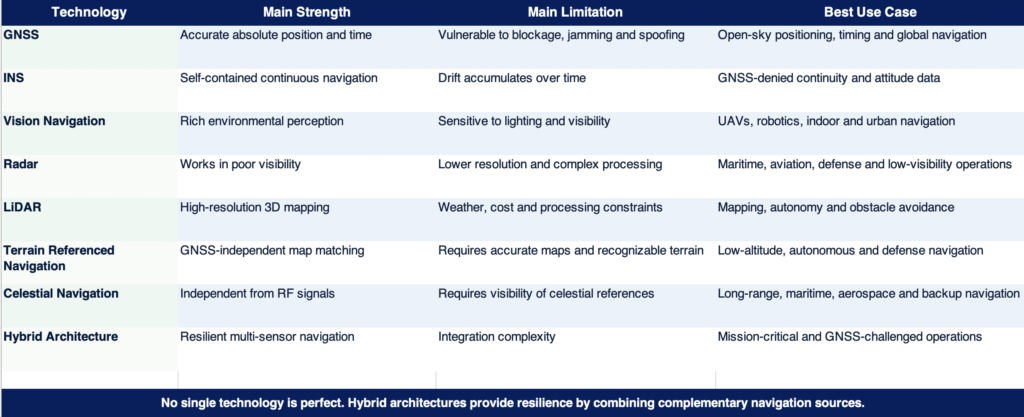
The right navigation technology depends on the mission.
A commercial surveying drone may prioritize GNSS, LiDAR and camera integration. A defense UAV may require INS, anti-jamming GNSS, vision navigation and terrain matching. A maritime vessel may rely on GNSS, INS, radar, compass and alternative references. A ground vehicle operating in forests or urban areas may need INS, odometer input, LiDAR, vision and GNSS when available.
Key selection criteria include:
Required accuracy
Operating environment
Expected GNSS availability
Exposure to jamming or spoofing
Platform dynamics
Mission duration
Sensor size, weight and power
Processing requirements
Cost and integration complexity
Need for real-time output
Reliability and redundancy requirements
For mission-critical platforms, navigation should be treated as a system architecture decision, not only as a receiver or sensor selection.
Navigation in GNSS-Challenged Environments
GNSS-challenged environments are becoming more common. Urban expansion, indoor operations, electronic warfare, interference, spoofing and autonomous mission requirements all increase the need for resilient navigation.
In these environments, hybrid architectures provide a practical path forward. GNSS remains useful when available, but the platform is not dependent on it alone. INS maintains continuity. Vision, radar, LiDAR and terrain reference sources provide additional corrections and situational awareness. Anti-jamming and anti-spoofing technologies strengthen GNSS reception and trust when satellite signals are still present.
This layered approach is central to Assured Positioning, Navigation and Timing. APNT is not a single device or sensor. It is an architecture designed to maintain trusted navigation and timing under real-world conditions.
Conclusion
Navigation technology is evolving from single-source positioning toward resilient, multi-layered architectures. GNSS remains essential, but it must be supported by complementary systems when reliability, continuity and trust are mission-critical.
INS provides the foundation for continuous navigation during GNSS outages. Vision, radar and LiDAR add environmental awareness and relative positioning. Terrain referenced navigation and celestial navigation provide alternative references. Sensor fusion connects these technologies into one coherent navigation solution.
For defense, aerospace, maritime and autonomous systems, the future of navigation is hybrid. Platforms must be able to use GNSS when it is available, reject it when it is compromised and continue navigating when it is denied.
General Guidance supports advanced navigation, positioning and resilient PNT solutions for demanding applications, helping customers evaluate the right technology architecture for platforms operating in GNSS-challenged, contested and mission-critical environments.